E-news #1:

Preliminary 3D geological models of Los Humeros and Acoculco geothermal fields as well as supra-regional conceptual model released

Philippe Calcagno, Gerardo Carrasco, Luis Negrin, Eugenio Trumpy, Guido Giordano

Resource Assessment and geological context deals with in-depth understanding of the edifice of geothermal systems, in view of temperature variations and of the relationships between geological structures and fluid pathways. This understanding is necessary to better determine the occurrence and location of the exploitable geothermal resources.

In a strong collaboration between the Mexican and the European scientists, a lot of knowledge and information on the two geothermal fields under investigation has been gathered in 3D geological models. Los Humeros regional and local (Figure 1), and Acoculco regional GeoModels consist in primary 3D interpretation of the main geological objects. The Los Humeros models are mainly based on a geological map [1], two geological cross sections [1,2] and well lithology provided by the CFE and was updated already by the newly mapped faults in the area. The Acoculco regional model is mainly constructed from a very recent geological map [3] and the interpreted geological cross-sections produced by a joint effort of EU and Mexican teams.

At the supra-regional scale, the conceptual model intends to present the geothermal system down to the Moho including the geothermal gradient. Two fieldwork campaigns have been conducted to update both the Los Humeros local and regional conceptual models with petrological structural and volcanological inputs. During the first fieldwork in May researchers collected samples from magmatic rocks and relative alteration systems. The second fieldwork in November 2017 was specifically dedicated to petrological and structural study.

The plumbing system started to be modelled to define the geometrical extent, location, longevity, temperature of the heat source. The basement rocks and the volcanic pile are to be reconstructed within their stratigraphic, alteration and structural settings also in terms of permeability and role within the geothermal system.

Read more: "3D preliminary geological models of Los Humeros and Acoculco geothermal fields (Mexico) – H2020 GEMex project" by Calcagno, P., Evanno, G., Trumpy, E., Gutiérrez-Negrín, L. C., Macías Vásquez, J. L., Carrasco, G., Liotta, D., and the GEMex T3.1 team, Advances in Geosciences (ADGEO)

[1] “Geologic Map of Los Humeros volcanic complex and geothermal field, eastern Trans-Mexican Volcanic Belt”, Carrasco-Núñez et al., Terra Digitalis, Vol 1 (2), 1-11, 2017, DOI:10.22201/igg.terradigitalis.2017.2.24.78

[2] “Reappraisal of Los Humeros volcanic complex by new U/Th zircon and 40Ar/39Ar dating: Implications for greater geothermal potential”. Carrasco-Núñez et al Geochemistry, Geophysics, Geosystems, 2018, DOI: 10.1002/2017GC007044

[3] “Geology of the Pleistocene Acoculco Caldera Complex, eastern Trans-Mexican Volcanic Belt (México)” by Denis Ramón Avellán et al. , under review in Journal of Maps

[4] Avellán, D.R., Macías, J.L., Layer, P.W., Sosa-Ceballos, G., Cisneros, G., Sánchez-Núñez, J.M., Gómez-Vasconcelos, M. G., López-Loera, H., Reyes-Agustín, G., Marti, J., Osorio-Ocampo, S., García-Sánchez, L., Pola, A., García-Tenorio, F., and Benowitz, J.: Geology of the Pleistocene Acoculco Caldera Complex, eastern Trans-Mexican Volcanic Belt (Mexico), Journal of Maps (submitted).

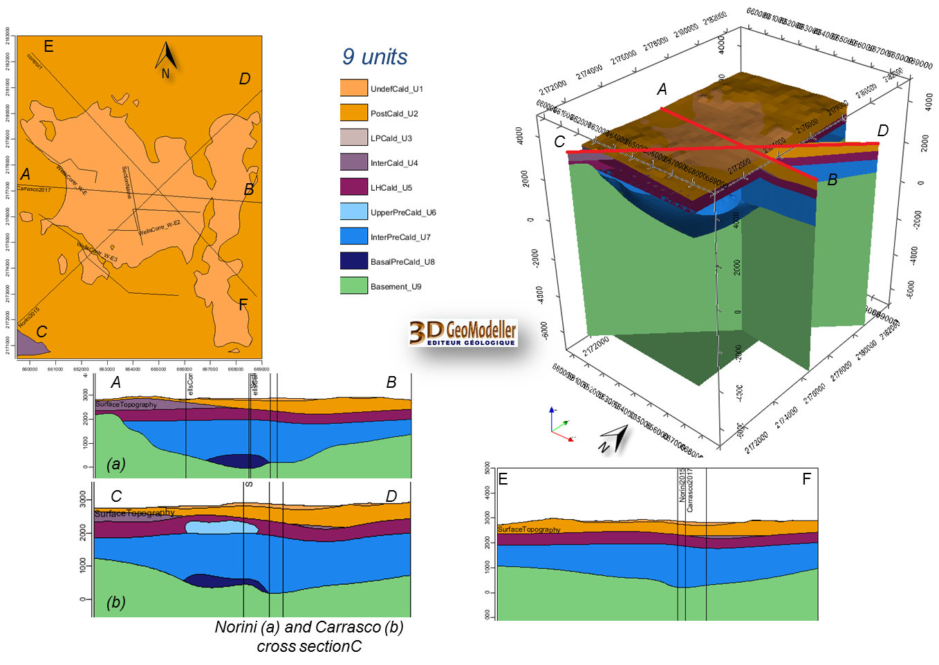
Figure 1:Examples of block model and cross sections of the Los Humeros preliminary local GeoModel.

E-news #1:

Characterising the influence of pre-existing structures on caldera evolution by analogue modelling

Marco Bonini, Giacomo Corti, Daniele Maestrelli, Domenico Montanari, Giovanna Moratti

GEMex researchers investigate the interplay between tectonics and magmatic processes in shaping volcanic edifices, focusing on specific volcano-tectonic issues that may be relevant for the exploration of the Los Humeros geothermal field. This study is been carried out through analogue modelling, which is an experimental technique that allows to study geological processes in the laboratory by analysing scaled physical models, built and deformed at reduced geometrical and temporal scales. Given the structural setting of the study area, scientists initially focused their activity on the collapse of calderas and volcanic edifices, and the associated surface and subsurface deformation pattern. Based on GEMex geologists’ observations that the pre-volcanic basement is affected by regional NE-ENE and NW trending fault systems, the researchers developed a series of analogue models exploring the role of pre-existing structures on caldera collapse.

The analogue models have shown that pre-existing discontinuities could strongly control caldera evolution. Various combinations among one or two fault-controlled straight sides in the magma chamber and discontinuities in the overlying brittle overburden have been considered in the modelling. The resulting structural patterns are complicated and differ significantly from a ‘standard’ evolutionary model of collapse over a symmetric (i.e., circular) reservoir. For example, a vertical discontinuity in the overburden forces the caldera to develop a straight side (Figure). This is similar to what is observed in several calderas worldwide including in Los Humeros. Deformation of models has been monitored through laser scanning and photographs, which have been used to implement PIV (Particle Image Velocimetry) analysis of model surface.

Figure: Analogue model investigating the effect of a magmatic chamber with a rectilinear side, mimicking a pre-existing fault. (a) 3D view and (b) top view of a collapsed caldera model. In this specific case, the discontinuity is also present in the brittle overburden above the rectilinear side of the analogue magmatic chamber. (c) Cross section AB of the model (trace of cross section AB is shown in “b”).

E-news #1:

Structural geology indicates that Acoculco might be suitable for EGS development


In the area around Acoculco, the collection of structural and kinematic data was dedicated to identify the main tectonic structures affecting the geothermal site. Two main trends were identified with NNW-SSE and SW-NE oriented structures, thus in agreement with the regional knowledge. The boreholes eventually considered for EGS development are located in an area affected by a SW-NE trending structure. This previously unknown information is of capital interest when the stress field of the area will be evaluated, in connection with the results from geophysics and modelling. Further studies will investigate the possibilities to connect the boreholes to the existing structures.

Additionally, images acquired by a drone were utilized to have a detailed view of key-outcrops, in order to have a meaningful database for an evaluation of the distribution of fractures, influencing permeability.

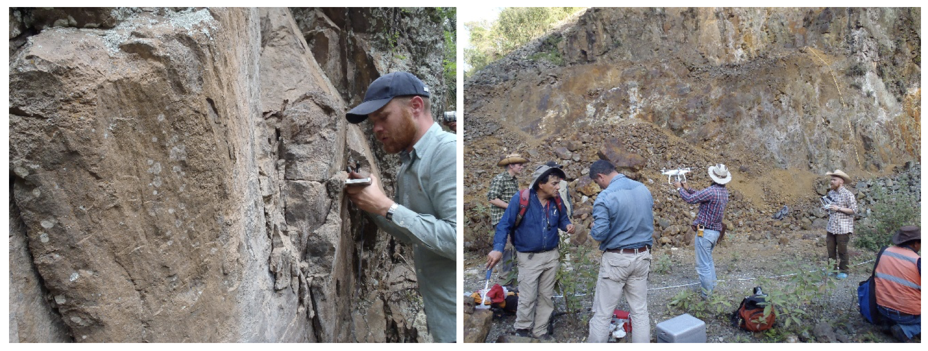
Figure 3: Structural geological measurements (left) and mapping of key-outcrops with a drone (right).

E-news #1:

Gaining understanding from exhumed fossil geothermal systems


The deep roots of the Las Minas fossil geothermal system, now exposed at surface, are considered an analogue of the Los Humeros active geothermal system. At Las Minas, GEMex researchers investigated the relationships between geological structures and paleo-geothermal fluid flow with the aim to shed light on the deep structures of the active Los Humeros field.

GEMex scientists concluded the collection of structural data and key-rock samples. Moreover, a few large key-outcrops were analyzed through acquisition of images from drone, thus permitting to study the 3D distribution of fractures, with fallouts on the evaluation of local paleo-permeability.

The first results indicate:

  • Two main regional trends, NNW-SSE and SW-NE oriented, were contemporaneously affecting the Las Minas area, favouring permeability. In particular, these were delimiting a structural depression where lacustrine sediments [1] deposited, the age of which is under study.

  • Volcanic activity is originated by deep sources made up of intrusive magma bodies that are precursor, coeval and subsequent, to the lacustrine deposition. Hydrothermal mineralization (skarn) is located within the cataclasites [2] of the brittle structures affecting the magma source (endoskarn) and the hosting rocks (exoskarn). Very often the skarn is present along sedimentary layers, indicating that the circulation of fluids was controlled by pre-existing foliations, too. The age of hydrothermal circulation is on course by radiometric dating (40Ar/39Ar method) studies of key-minerals.

  • Fluid inclusions (i.e. portions of parental fluids remained trapped during crystallization) analysis indicate that the circulating paleo-fluid was characterized by high salinity and temperature, suggesting a contribution of magmatic fluid to the hydrothermal system.

  • The localization of skarn deposits, markers of paleo-fluid path, indicates that the system of regional fractures are the most efficient targets for a future exploration.

Today, the activity is focused on integration of data, interpretation and development of the conceptual model. All the activities were carried out in collaboration between Mexican and European colleagues, in a positive and fruitful framework of cooperation and friendship.

[1] Lacustrine sediments: deposits in the bottom of ancient lakes carried by a river or steam channel

[2] Cataclasite: rock formed by fracturing and comminution during faulting

[3] Foliations: repetitive layering

Read more: Deliverable 4.2: Final report on understanding from exhumed systems […]

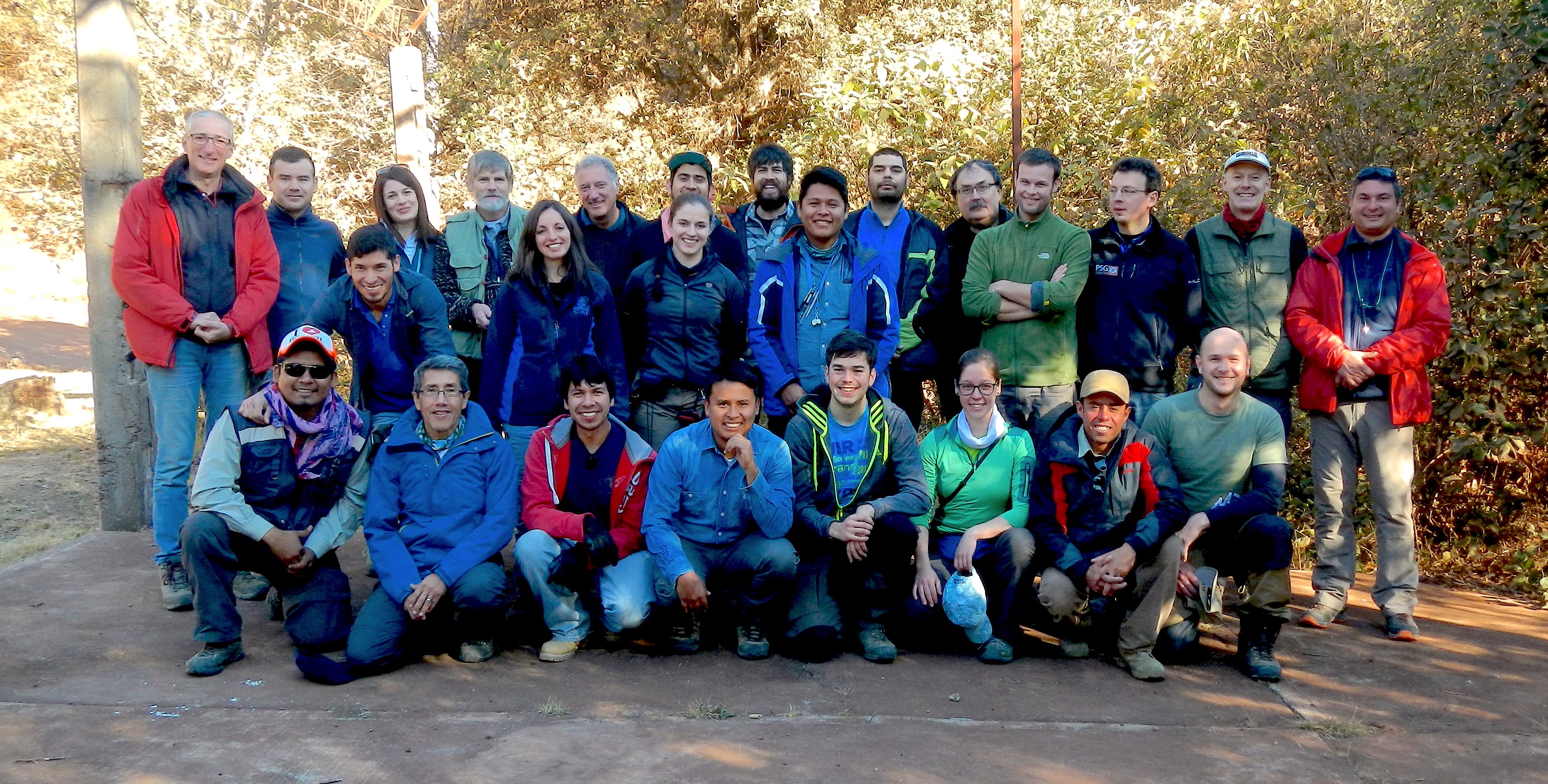
Figure 2: The European and Mexican joint-group during our common fieldwork in January 2018

E-news #1:

Geophysical surveys in Acoculco and Los Humeros (almost) completed


At both geothermal sites considered in the GEMEx project, researchers from the European and the Mexican consortiums have conducted resistivity (MagnetoTelluric MT and Transient ElectoMagnetic TEM), gravity and seismic surveys.

MT resistivity data were collected in two phases through a joint effort by the Mexican and European consortiums in late 2017 and in April/May 2018. In Los Humeros, a total of 123 MT soundings were performed and 68 MT soundings in Acoculco. The TEM survey will be finalized in September. Processing of the MT data is finished and resistivity models based on 1D joint inversion of the MT and TEM data will be available in October and on 3D inversion towards the end of the year for both fields.

Gravity surveys in both Los Humeros and Acoculco were done by the Karlsruhe Institute of Technology KIT (Europe) and the Ensenada Center for Scientific Research and Higher Education CISESE (Mexico) – a total of 429 measurement points for both areas. Bouguer gravity maps will be available in October.:

In Los Humeros 43 seismometers have been collecting earthquake data since October 2017 and 16 seismometers were located in Acoculco in May 2018. Recording of seismic data is ongoing and will continue until October 2018 in Los Humeros and until March 2019 in Acoculco, while processing of first data is performed in parallel.

InSAR crustal deformation data have been obtained and analysed. Integration of methods and inversion constraints is ongoing in particular as more geophysical information become available.

In general geophysical surveys in Acoculco were a challenge, not only due to the altitude of the area and the sometimes rainy weather conditions. From the beginning of the project the permission for geophysical studies were difficult to obtain since some indigenous people are living in the area. The permission from the Mexican ministry to perform the field work was obtained in December 2017. Nonetheless, when the researchers arrived in the area, they had to obtain permission from the local people to work on their land. Claudia Arango from UNAM gave an excellent presentation to about 50 locals from the communities surrounding the study area. Afterwards most people agreed to the surveys and the data collection was successfully completed.

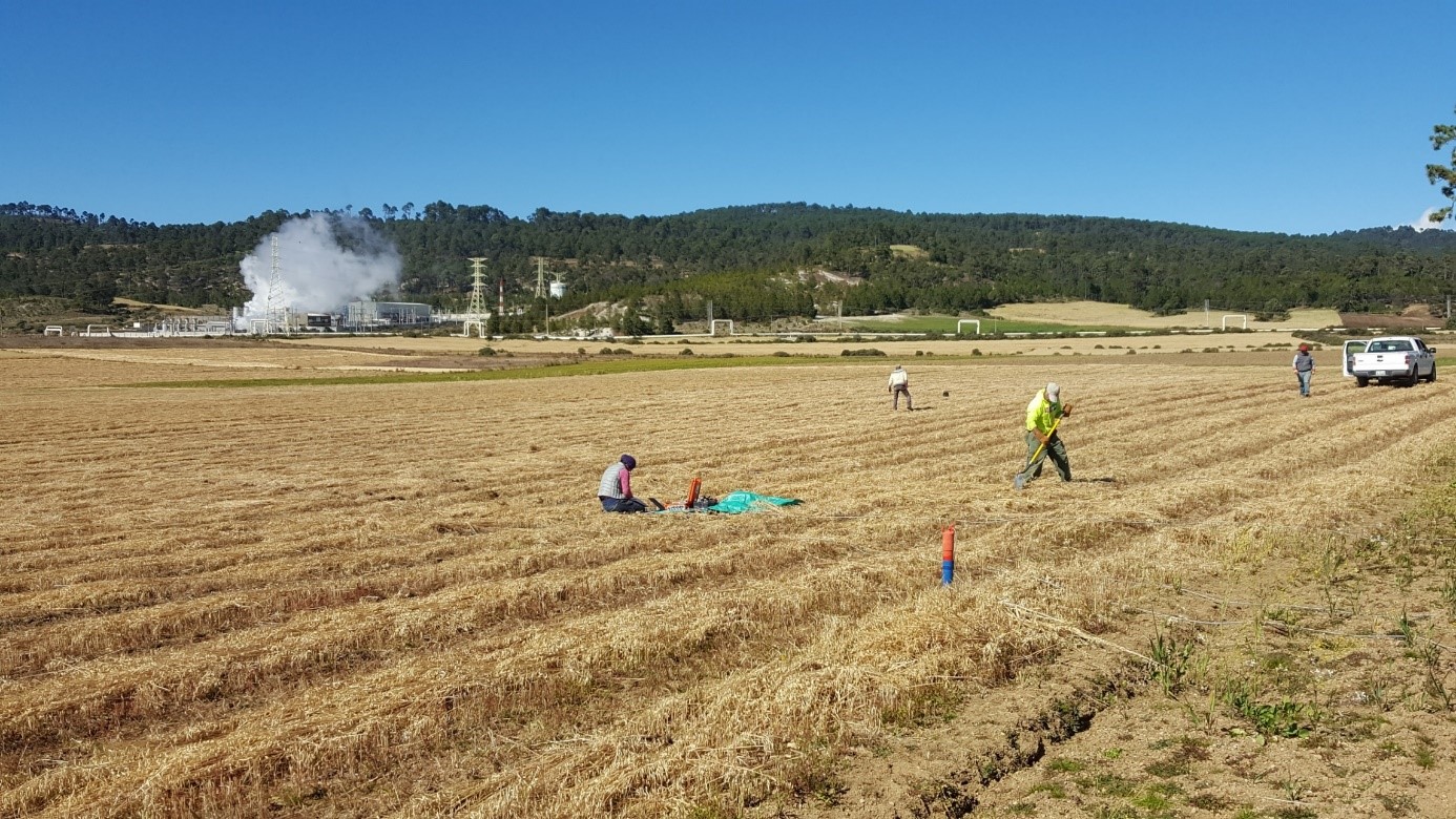
Figure 4: Setting up an MT station in Los Humeros