E-news #1:
Preliminary 3D geological models of Los Humeros and Acoculco geothermal fields as well as supra-regional conceptual model released
Philippe Calcagno, Gerardo Carrasco, Luis Negrin, Eugenio Trumpy, Guido GiordanoResource Assessment and geological context deals with in-depth understanding of the edifice of geothermal systems, in view of temperature variations and of the relationships between geological structures and fluid pathways. This understanding is necessary to better determine the occurrence and location of the exploitable geothermal resources.
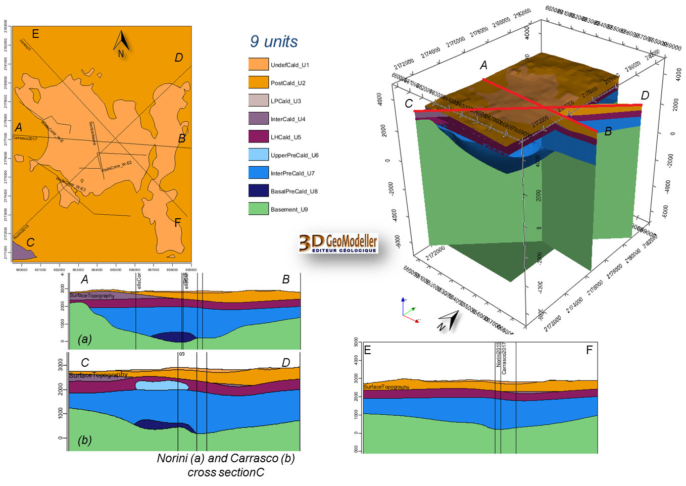
In a strong collaboration between the Mexican and the European scientists, a lot of knowledge and information on the two geothermal fields under investigation has been gathered in 3D geological models. Los Humeros regional and local (Figure 1), and Acoculco regional GeoModels consist in primary 3D interpretation of the main geological objects. The Los Humeros models are mainly based on a geological map [1], two geological cross sections [1,2] and well lithology provided by the CFE and was updated already by the newly mapped faults in the area. The Acoculco regional model is mainly constructed from a very recent geological map [3] and the interpreted geological cross-sections produced by a joint effort of EU and Mexican teams.
At the supra-regional scale, the conceptual model intends to present the geothermal system down to the Moho including the geothermal gradient. Two fieldwork campaigns have been conducted to update both the Los Humeros local and regional conceptual models with petrological structural and volcanological inputs. During the first fieldwork in May researchers collected samples from magmatic rocks and relative alteration systems. The second fieldwork in November 2017 was specifically dedicated to petrological and structural study.
The plumbing system started to be modelled to define the geometrical extent, location, longevity, temperature of the heat source. The basement rocks and the volcanic pile are to be reconstructed within their stratigraphic, alteration and structural settings also in terms of permeability and role within the geothermal system.
Read more: "3D preliminary geological models of Los Humeros and Acoculco geothermal fields (Mexico) – H2020 GEMex project" by Calcagno, P., Evanno, G., Trumpy, E., Gutiérrez-Negrín, L. C., Macías Vásquez, J. L., Carrasco, G., Liotta, D., and the GEMex T3.1 team, Advances in Geosciences (ADGEO)
[1] “Geologic Map of Los Humeros volcanic complex and geothermal field, eastern Trans-Mexican Volcanic Belt”, Carrasco-Núñez et al., Terra Digitalis, Vol 1 (2), 1-11, 2017, DOI:10.22201/igg.terradigitalis.2017.2.24.78
[2] “Reappraisal of Los Humeros volcanic complex by new U/Th zircon and 40Ar/39Ar dating: Implications for greater geothermal potential”. Carrasco-Núñez et al Geochemistry, Geophysics, Geosystems, 2018, DOI: 10.1002/2017GC007044
[3] “Geology of the Pleistocene Acoculco Caldera Complex, eastern Trans-Mexican Volcanic Belt (México)” by Denis Ramón Avellán et al. , under review in Journal of Maps
[4] Avellán, D.R., Macías, J.L., Layer, P.W., Sosa-Ceballos, G., Cisneros, G., Sánchez-Núñez, J.M., Gómez-Vasconcelos, M. G., López-Loera, H., Reyes-Agustín, G., Marti, J., Osorio-Ocampo, S., García-Sánchez, L., Pola, A., García-Tenorio, F., and Benowitz, J.: Geology of the Pleistocene Acoculco Caldera Complex, eastern Trans-Mexican Volcanic Belt (Mexico), Journal of Maps (submitted).
 Figure 1:Examples of block model and cross sections of the Los Humeros preliminary local GeoModel.